Location-data
Festung St. Malo.
AOK 7, KVA A1, KvGr. Rance, KvUGr. Festung St. Malo.

Through the ages the historic city of St. Malo was always an important and strategic harbour place, lying in the centre of the Golf of St. Malo. The harbour of St. Malo was also the main supply and connective harbour for the English Channel Islands Jersey, Guernsey and the others.
In front of the harbour are several islands, which makes it difficult to attack the harbour, because of too many obstacles in and underwater in combination with the great differences between low and high water. In the past many of those islands where integrated in the defence of the city by building fortifications.

After the invasion of the Germans in May 1940 and the surrender in June, the Germans took over the harbour and its defence systems which were already in place. From here on they also started the invasion and occupation of the Channel Islands.
Soon the Germans started building their defence system by placing heavy gun positions in open emplacements and bunkers to protect the harbour. All these building activities where lead by the German "Festungspioniere" and were mainly built by the German building organisation called "Organisation Todt" (OT).
The defence status around the city of St. Malo was in the beginning classified as a "Verteidigungsbereich" (VB), but in January 1944 it was transferred by order of Hitler, together with other larger harbours along the Atlantic coast, into a "Festung".

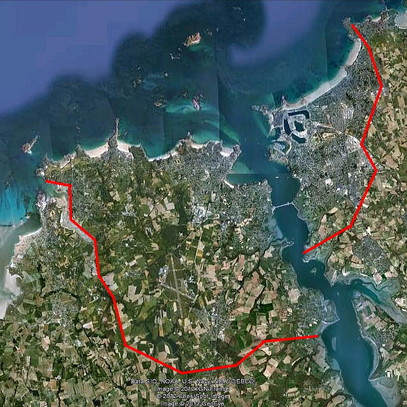
The Festung St. Malo started in the north at the Point de la Varde, from here the Landfront went with a big curve inland and passed the river Rance between La Madeleine and La Richardais on the south bank. From here it went on around Pleurtuit towards the coast by Lancieux. In total the Festung was about 25 square kilometres, they planned to build about 350 St-bunkers and about 5700 soldiers had to defend the Festung St Malo to its bitter end…..!
The German garrison of the Festung St Malo surrendered to the American troops, after heavy fights and bombardments from sea and by air, on September 2nd 1944.


We used a lot of information from the book from Hans Sakkers, Festung St. Malo (2001 in dutch), and other internet sources.
France, Ille-et-Vilaine, Festung St. Malo.
Ille-et-Vilaine (35)

North section Festung St Malo:
Ra Nr.    Name                   place/area
Ra 109    Fort de la Varde - Rotheneuf.
Ra 111    Point de Rochebonne - St.Malo/Pnt Rochebonne.
Ra 119    Lorette - St.Malo/Lorette.
Ra 160    M.Flak Batt. Parame - Saint Ideuc.
Ra 160a  Batt. 405 - St.Malo/Les Ormeaux.
Ra 221    Stab. Flak Abt.343 - Rotheneuf.
Ra 230    Fort de la Cité d'Alet/Die Zitadelle - St. Servan.
Ra 275    Hotel Victoria -St. Servan.
Ra 277    M.K.B. Cécembre/Ostwall - Ile Cécembre.
Ra 281    Arsenal - St. Servan.
Ra 281a   Le Rosias - St. Servan.
Ra 601    La Haize - St.Malo/La Haize.
Ra 603    Saint Ideuc - Saint Ideuc.
Ra 606    La Baneville - Saint Ideuc.
Ra 611    Le Val - St.Malo/La Val.


South section Festung St. Malo:
Ra Nr.    Name                   place/area
Ra 120    Point de la Vocomteè - Dinard/Guais.
Ra 122    Av. De la Vicomte - Dinard/Guais.
Ra 128a  Le Ville Es Metetz - Le Ville Es Metetz.
Ra 129    Quai du Prieure - Dinard/Guais.
Ra 130    Port de Plaisance - Dinard.
Ra 131    Point du Moulinet - Dinard.
Ra 136    Point de la Roche Pelée - La Fourberie.
Ra 136b  Anse de Port - La Fourberie.
Ra 138    M.K.B. Point de Bellefard - Les Hayes.
Ra 142    Point du Décollé - Saint Lunaire.
Ra 143    Plage de Longchamp - Saint Lunaire.
Ra 144    Le Tertre aux Scènes - Saint Lunaire.
Ra 145    Paulus - La Chapelle/Point de la Garde Guérin.
Ra 145a  Dunes de Port Hue - La Chapelle/Le Port Hue.
Ra 150    Le Chateau le Nessay - La Chapelle/Chateau.
Ra 150a  Plage le Nessay - La Chapelle/Plage le Nessay.
Ra 151    Le Tetre Gondan - Saint Briac sur Mer.
Ra 156    H.K.B. 1271 - La Richardais.
Ra 156alt La ville Nisan - La ville Nisan.
Ra 157    La Brousette Battery - La Ville es Lemetz.
Ra 236/I  Portual Belle - Pleurtuit.
Ra 236/VIII Le Bourgneuf - Pleurtuit.
Ra 237    Hv. Flak batt. Le Haut Chemin - Dinard/Guais.
Ra 658    Le Minihec-sur-Rance - Le Minihec-sur-Rance.
Ra 660    La Marquerais - Le Minihec-sur-Rance.
Ra 662    La Vieuville - Pleurtuit.
Ra 666    roundabout D266 & 118 0 Pleurtuit.
Ra 670    Les Rues - Les Rues.
Ra 675    Le Point és Omnés - Le Point és Omnés.
Ra 680    La ville au Monnier - La ville au Monnier.